


Northwest Iowa — Some severe winds blew through northwest Iowa as part of a thunderstorm complex on Wednesday afternoon, according to the National Weather Service.
According to the weather service, the reports of wind and wind damage started in our four-county area at 1:17 p.m. with a 52 mph wind gust two miles south of Lester. At 1:31 p.m., there was a report of a 59 mph gust two miles southeast of Rock Rapids. At that same time, a roof was blown off of a hog barn, according to the weather service, four miles northeast of Rock Rapids. Then a few minutes later, there was a wind gust of 62 mph four miles south-southeast of Rock Rapids. About 15 minutes later, there was a report of trees down a mile north of Little Rock. Then about 2:00 p.m., a 73 mph gust was reported three miles northeast of Sibley, with a 61 mph gust reported five minutes later four miles north-northeast of Sibley.
We talked to Sibley Fire Department Assistant Chief Dan Bechler, and he tells us his perspective on what happened.
He tells us what emergency responders were doing as of mid-afternoon Wednesday.
He says for a short time, they had people shelter in place, and as of mid-afternoon Wednesday, they still didn’t really want people to come into Sibley.
Bechler tells us that after they made sure that everyone is safe and not in any danger, they were going to begin to compile damage reports to send to the National Weather Service.
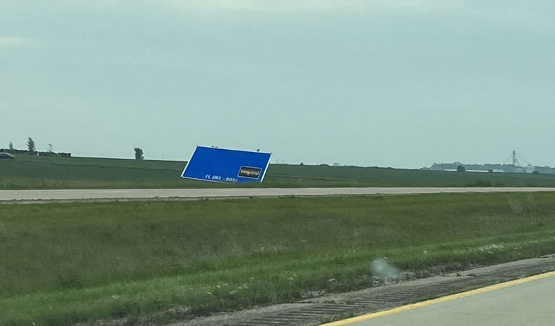
We are also told that multiple semis were pushed over on Highway 60 near Sibley, and there were social media videos of tornadoes in the area.
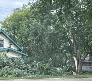
photos courtesy of Sharia Snedeker
Top photo: tree damage in Sibley
Below: a semi that was blown over being recovered by Adrian Auto, and a freeway local services sign snapped in the wind